Smoke from fires is causing a lot of haze and unhealthy air.
This website provides data and maps about air quality and fires: https://www.airnow.gov/about-airnow/
 |
| Click to enlarge. |
Air quality appears to be very bad in the northern Great Plains.
People are being advised to stay indoors in Bismarck, North Dakota.
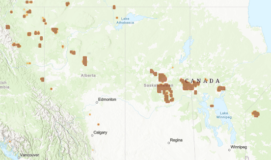
Where is the smoke coming from?
Canada.
 |
| Prince Albert vicinity |
 |
| Further northwest |
 |
| Highway 58 fire(s). |
Readers can decide for themselves whether these hot spots (fires) are occurring naturally...
... or not.
Mainstream media has reported about the fires...
But they have not reported about the cause, or even mentioned the website or data shown at the top of this MFP article. This is all they report...
UPDATE, June 2, 2025...
One day later, the Highway 58 fire(s) have spread some, but are largely diminished. This is in a remote part of of northwestern Alberta, Canada.
 |
| Click to enlarge. |
 |
| Oil Field |
The Winefred Lake oil field, shown above, is near Conklin, which is in the eastern part of the Athabasca Oil Sands region.
Editorial
Oil and gas burn easily, and those who are in the business of extracting them from the land are typically very careful about avoiding ignition sources.
The Winefred Lake fire(s) occurred yesterday right in the middle of an oil field, and they formed a long, oval shape extending a considerable distance from the extraction equipment.
Today, those fires are out. Undoubtedly, personnel in the Conklin area quickly extinguished them.
How did those fires start? Do the oil field employees know? Do they have ideas about it? Did they see anything suspicious? Have they been interviewed by the press or media? Has anyone even talked to them?
Given the extent of the environmental impact these "fires" are having, it seems like reporters would investigate more. Oh, wait! That's precisely what the Michiganian Free Press is doing!
UPDATE, June 4, 2025...
In a flat, treeless environment like the Canadian Great Plains,1
... how do fires (the brown splotches)...
... propagate hundreds of feet?
... or thousands of feet,
... without affecting the grass in between?
Even the satellite photo in USA Today (above) shows discrete fires great distances apart, ...with nothing burned between them. They are all separate fires.
 |
| Click and enlarge to view between the fires. Where is the char? |
How do these fires get started in the first place when they are hundreds of miles apart in remote areas with few roads?
Zipidy DEW ... Duh??
 |
| DEW stands for Directed Energy Weapon (artistic rendering). |
UPDATE, June 5, 2025...
This is ridiculous. Wildfires do not jump across water and spread like this.
 |
| Click to enlarge. |
1 Actually, the following photo is a Google Earth "Street View" of a road on the eastern side of Amisk Lake near some of the fires. These fires are generally in areas like this, not plains.
UPDATE, June 6, 2025...
If an earth-orbiting satellite were being used to start these fires, and the direction of the beam depended upon the orientation of the satellite, that satellite would need to be moved to adjust its target.
Reorienting a satellite requires time and energy, and it seems reasonable consecutive targets would be close together.
The satellite's orbital dynamics would be different than the rotational dynamics of the earth, and it seems reasonable they would interact to create characteristic patterns.
In the opinion of the MFP, the patterns of these fires are extremely suspicious and cannot be considered to be naturally occurring.
The MFP calls for the immediate suspension of these activities and the arrest of those who are perpetrating them. Those misusing equipment and facilities owned by the American people must be subjected to military justice. This is unacceptable and inexcusable.
UPDATE, June 8, 2025...
Nothing like a little rain to dampen a DEW-ignited, "wildfire" fest.
The orange dot under the "CA" of CANADA in the middle of the image, above, is an air monitoring station in Flin Flon on the border of Saskatchewan and Manitoba.
The image, below is the same region shown in the June 6 update of this article, above, the one with all of the "wildfires".
Apparently a little rain put an end to that sideshow narrative.
UPDATE, 11:00 PM EDT (23:00)...
What's happening in Mexico?? That was not there earlier in the day.
UPDATE, July 15, 2025...
The Fiduciary has noticed all the fires, and has attributed them to DEW's.
And now they are treating us to DEW fires and Scalar Tech floods and pandemics, too. (AVR #5457).
Her Union State (alaska) has experienced more than its share of "wildfires" this summer.
The MFP is very curious to learn about "Scalar Technology," once the secrets become public knowledge.
UPDATE, July 31, 2025...
"Lightning?"
UPDATE, August 2, 2025...
"Human." That makes more sense.
The MFP believes this looks like disclosure. This morning's Air Quality Alert contains a link to the AirNow website used to document this MFP article...Everything shown in this MFP article is easily available to the public.


No comments:
Post a Comment